Performed ground penetrating radar (GPR) surveys of nine road segments spread out through Clear Creek County, CO. The goal of the surveys was to detect any conduits passing under the road to improve flood control in the country during flash flood events.
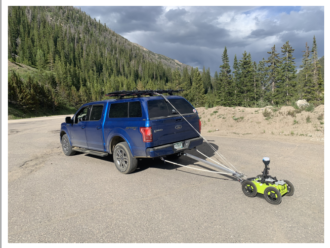
The secondary goal was to map asphalt thickness, while the tertiary goal was to map depth to bedrock. The towing system seen in the figure was built to accomplish these goals. An Impulse Radar PinPointR GPR was used for the surveys as it offers 400 and 800 MHz antennas and real-time sampling (RTS). The RTS allowed us to collect at faster speeds and have better signal-to-noise ratios which increases the depth of penetration. Positioning was done with a pair of EMLID Reach RS2 GNSS receivers in both real-time kinematic (RTK) mode and post-processed kinematic mode (PPK).